Problem Statement
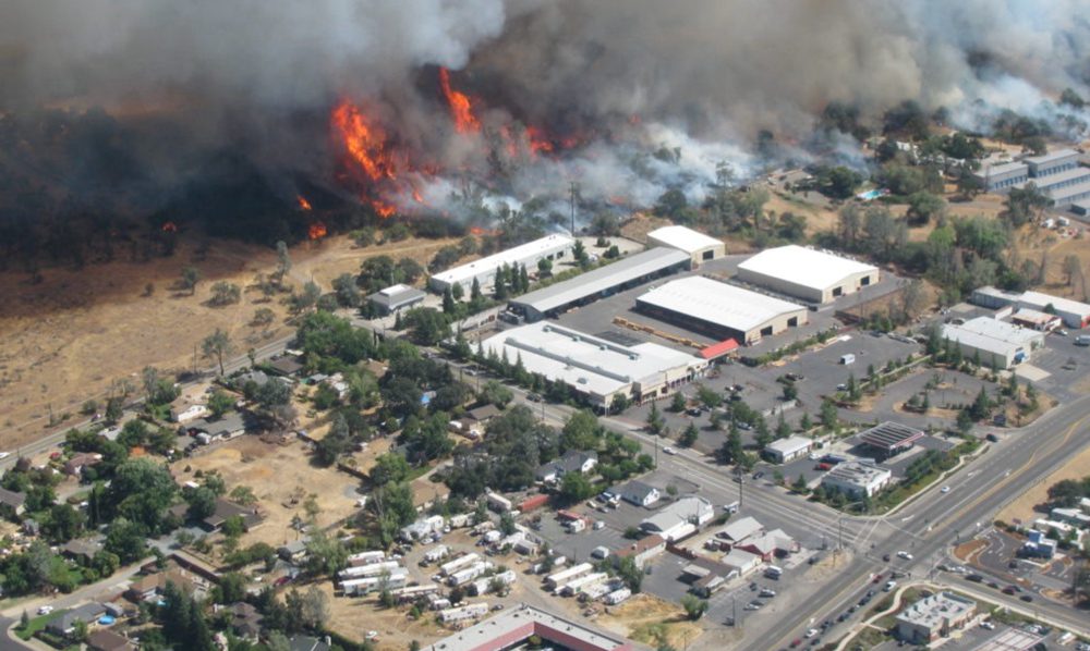
Seven of the ten most destructive fires in California have occurred in the last five years2, and one in four Californians lives in an area considered high-risk for wildfires3. These problems can be addressed by focusing on local planning and land use decisions that are guided by a community’s “network of plans.”
However, communities in California and across the U.S. increasingly adopt many different plans in their “network of plans” — e.g., General (Comprehensive) Plan, Hazard Mitigation Plan, Community Wildfire Protection Plan, Climate Action Plan, and various sectoral or area plans. Often produced by multiple “siloed” departments or stakeholder groups with limited coordination or spatial understanding, these plans are frequently poorly integrated and may, in fact, exacerbate vulnerabilities including the risk of wildfire especially in the wildland urban interface (WUI).
A New Approach
- To address this critical issue, we are developing the Plan Integration for Resilience Scorecard™ (PIRS™) for Wildfire, a method that enables the systematic and spatial evaluation of a community’s network of plans to strengthen wildfire resilience and reduce vulnerability.
- Collaborating with several California communities, we aim to harmonize the guidance provided by their networks of plans, assessing their plans spatially and through the lens of wildfire risk to facilitate adjustments that improve coordination, and strengthen wildfire resilience in the most vulnerable locations.
- The PIRS™ method used on this project was originally developed for flooding hazards with funding from the Department of Homeland Security Science and Technology Directorate. It has since been adopted as a preferred method by the American Planning Association (APA).4
Method
The PIRS™ for Wildfire process involves the following steps:
1) Delineate “district-hazard zones”
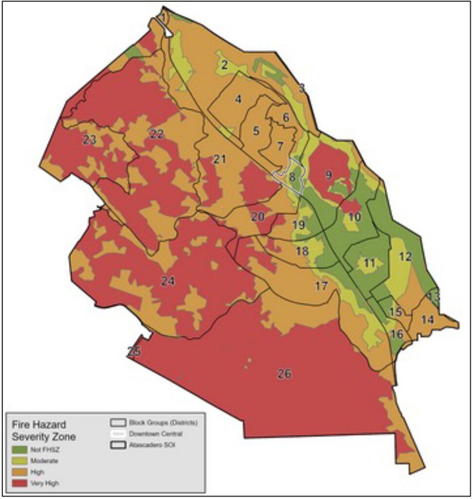
To reduce “ecological fallacy”5 issues and enable spatial plan and policy evaluation, the community is first subdivided into relevant planning districts (e.g., neighborhoods, U.S. Census block groups) and hazard zones (e.g., Fire Hazard Severity Zones), which are combined using GIS to form a layer of mutually exclusive “district-hazard zones”, the spatial unit of analysis for a PIRS™ for Wildfire analysis.
2) Review the community’s network of plans
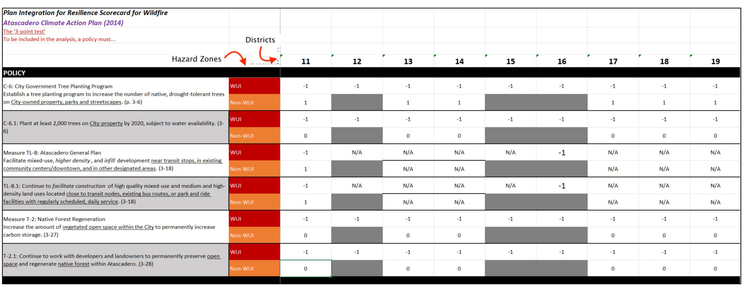
The community’s network of plans (e.g., General Plan, Hazard Mitigation Plan, CWPP, Climate Action Plan) is then closely reviewed for actionable policy statements that are likely to affect wildfire resilience, either positively or negatively, and that contain some sort of place-specific term that helps identify where they apply (and where they do not). Relevant policies are added to the scorecard.
3) Evaluate plans spatially
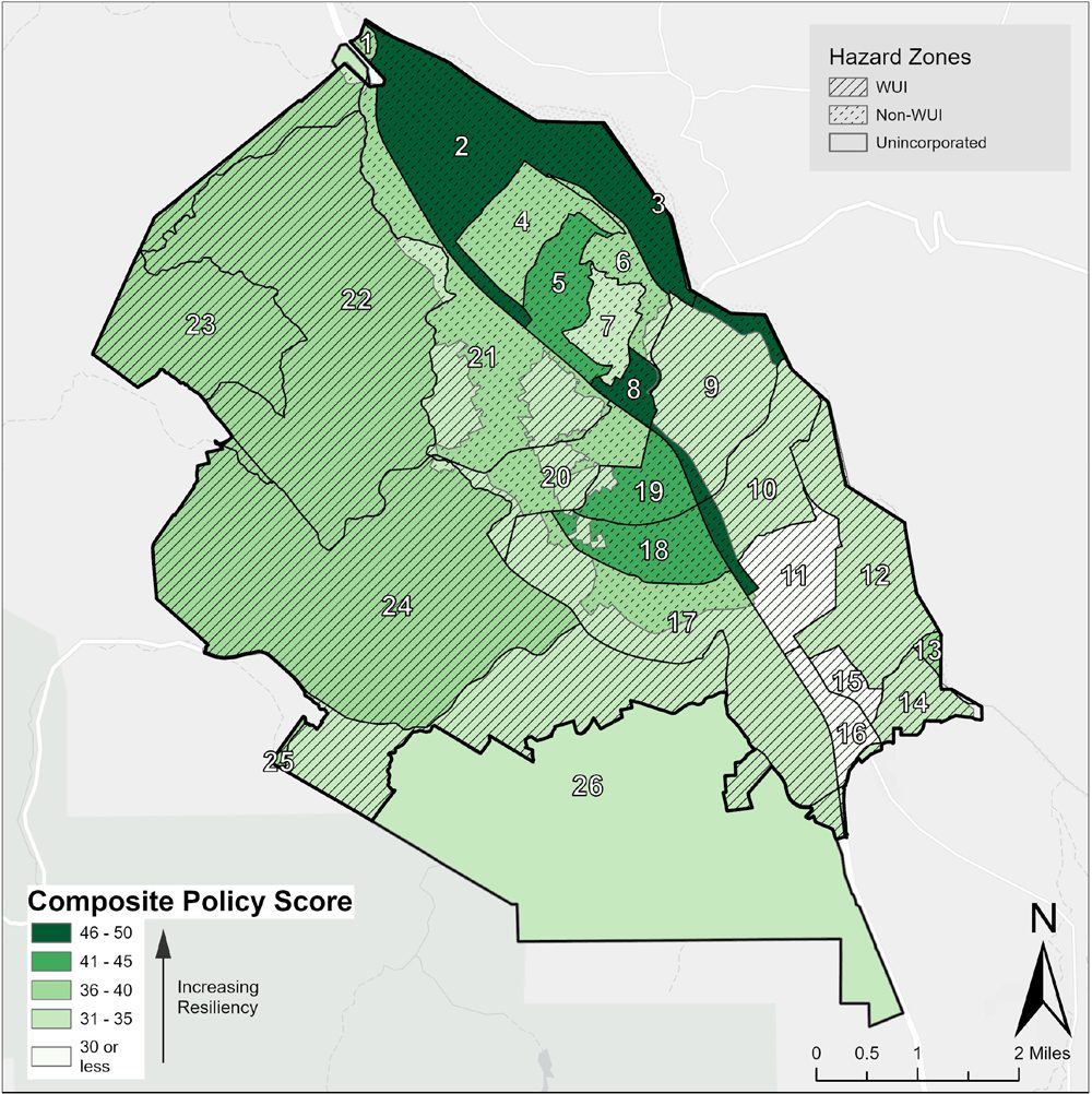
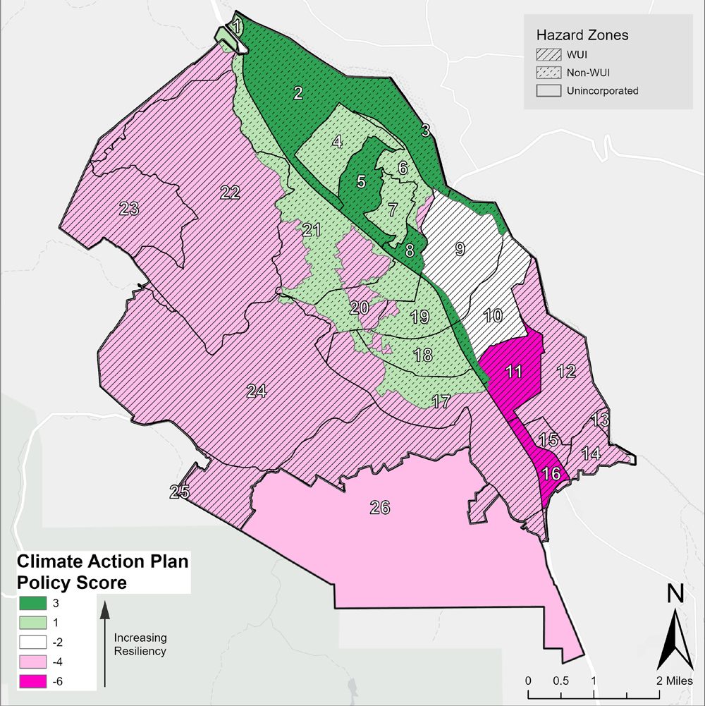
Each policy is then given a score of “+1” (increases wildfire resilience), “-1” (decreases resilience), or “0” (neutral) and assigned to the appropriate district-hazard zone(s) based on its place-specific term. This is repeated for all relevant policies across the community’s entire network of plans. Scores are then summed for each district-hazard zone.
4) Assess vulnerability (optional)
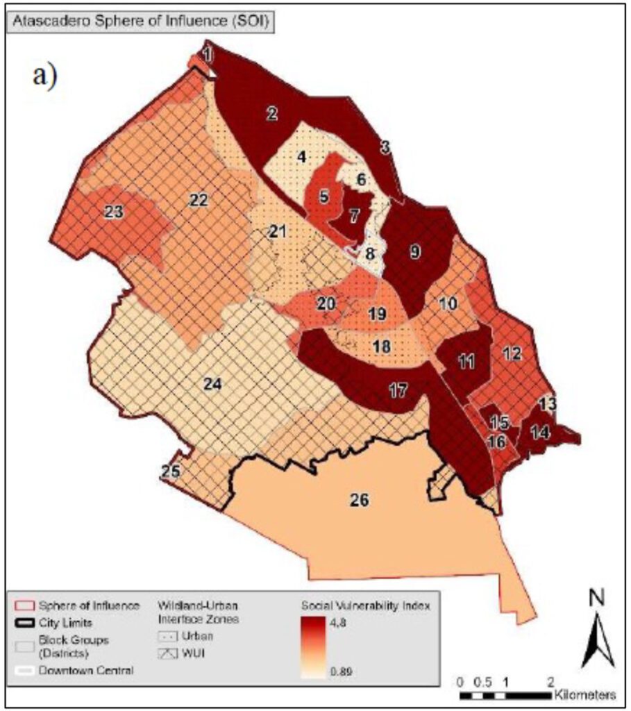
Social, physical, or other types of vulnerabilities can also be spatially assessed and compared to the spatial plan evaluation. The location of critical facilities or evacuation routes may also be considered.
5) Analyze results
Tables and maps of the results help identify spatial patterns, synergies, conflicts, and gaps in the community’s network of plans and policies and how it is likely to affect wildfire risk.
6) Advance plan integration and wildfire resilience
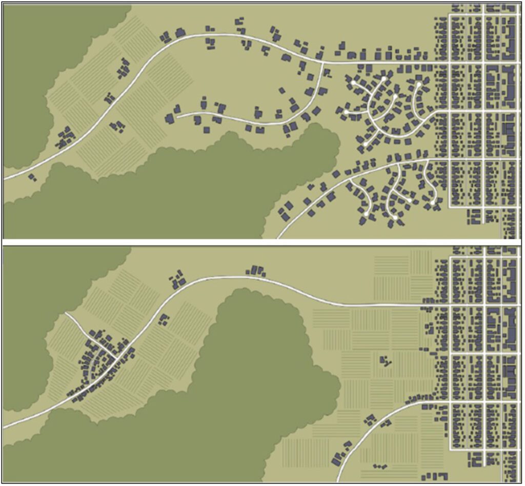
Guided by the spatial and hazard-focused PIRS™ for Wildfire analysis, community plans can then be improved by adjusting or adding policies (e.g., clustering development in the WUI) to resolve identified conflicts and strengthen wildfire resilience.
Preliminary Findings
- Early results suggest that the PIRS™ method is effective in the context of wildfire. Our community partners are engaged with and learning from the process.
- The new perspective and data are helping communities better understand the effects of their plans and policies of wildfire risk.
- The focus on hazards and the spatial framework reveals patterns of policies that support wildfire resilience, “hot spots” of policy conflict, and “cool spots” with limited policy attention.
- Vulnerability assessments provide additional insight into areas of need in the communities.
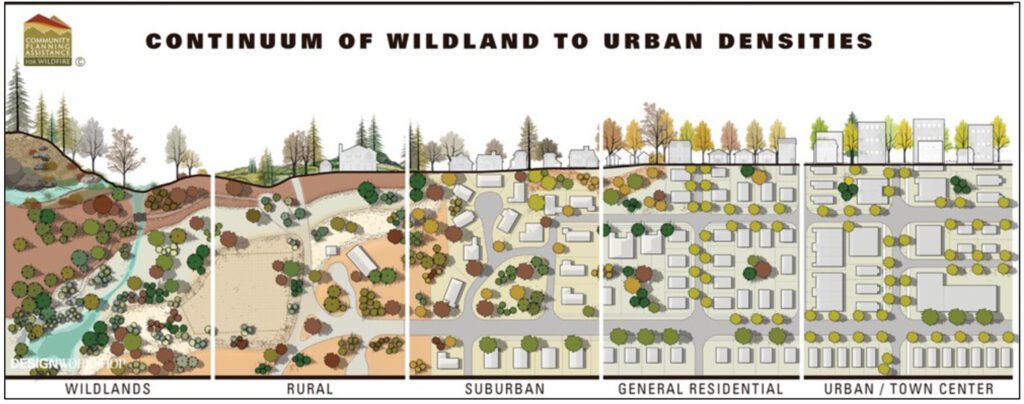
- The fuel path disturbance conceptual approach (i.e., fire spread structure-to-structure, structure-to-vegetation, and vegetation-to-vegetation) is one of the conceptual frameworks being developed as part of the PIRS™ for Wildfire process.
Next Steps
- Assist our municipal partners – Atascadero and Temecula – in their use of the PIRS™ for Wildfire results to guide their general plan update processes (and network of plans updates) to strengthen integration and wildfire resilience.
- Continue with our county partners – Santa Barbara County and Sonoma County – to expand the analysis to meet their planning goals and explore the potential of “nested” PIRS™ for Wildfire evaluations at multiple scales.
- Develop a PIRS™ for Wildfire Guidebook, based on these initial applications and community collaborations.
- Advise communities on how to use the perspective, knowledge, and empirical data gained through the PIRS™ for Wildfire process when applying for federal and state wildfire mitigation grants.


- https://elitecommandtraining.com/course-calendar/s-215-fire-operations-wildland-urban-interface-wui-newport-beach-fs-7-april-2020/ (accessed 10/30/23)
- https://www.fire.ca.gov/our-impact/statistics (accessed 10/30/23)
- https://ccst.us/wp-content/uploads/The-Costs-of-Wildfire-in-California-FULL-REPORT.pdf
- https://www.planning.org/learn/course/9250858 (accessed 10/30/23)
- Piantadosi, S., Byar, D. P., & S. B. Green (1988). “The ecological fallacy,” The American Journal of Epidemiology, 127(5), 893-904.
- https://transect.org/modules.html (accessed 10/30/23)
- https://cms5.revize.com/revize/wascocounty/WUI%20Visuals%20Community%20Guide_2018.pdf (accessed 10/30/23)

