Case Study Dates: 2020; 2021
Norfolk is a Virginian city along the Atlantic Coast with a population of 244,076. It is the home of the largest naval base in the world, which is the city’s primary economic pillar. Many parts of Norfolk are prone to frequent coastal storm flooding and/or high-tide flooding.
Summary of Findings
The capacity of Norfolk’s network of plans in reducing flooding vulnerability is inconsistent between different parts of the city. In particular, some more vulnerable communities receive comparatively little policy attention.
Plans Evaluated
- Norfolk 2030: The General Plan for the City of Norfolk
- Hampton Roads Hazard Mitigation Plan
- Sand Management Plan Guidance Document
- Norfolk Vision 2100
- Downtown Arts and Design District Plan Revitalization Strategy
- Military Circle/Military Highway Urban Development Area: A Vision for the Future
Norfolk, VA
Norfolk is located along the Atlantic Coast. It is exposed to increasingly frequent flooding due to coastal storm surge and sea level rise, which happens twice more significantly than the global average in Norfolk. Additionally, flood events in Norfolk are not merely triggered by heavy rains or hurricanes. Flooding also occurs during blue skies, at high tide, or when the winds come from the right direction. About 16% (8.3 square miles) of the total geographic area (52 square miles) is within the 100-year floodplain boundaries as defined by the Digital Flood Insurance Rate Maps (DFIRM) of the National Flood Insurance Program (NFIP). An additional 32% (16.6 square miles) of the city’s area may be added to the 100-year floodplain by 2100 due to sea level rise (City of Norfolk, 2017).
Norfolk has long taken a leadership role in community resilience. According to Paula Shea, the city’s Chief Planner, Norfolk inspires to be a “model community on resilience.” The city is a participant in the Rockefeller Foundation’s 100 Resilient Cities program, which resulted in the adoption of the Norfolk Resilience City Strategy and the hiring of a Chief Resilience Officer in 2014. Norfolk also hosted the Dutch Dialogues workshop in 2015 to bring together Dutch engineers and city planners with local counterparts to explore innovative solutions to the challenges inherent to living in a coastal city (Work Program Architects [WPA], 2015). The focus of the workshop was to extend beyond the conventional structural approach of building higher barriers to explore how to live more naturally with water. These activities culminated into the preparation of a forward-looking Norfolk Vision 2100, which responds to sea level rise and coastal storm hazards. The vision includes the principles to guide the development of a new comprehensive plan in the years 2020-2021.
Findings of the Overall Network of Plans:
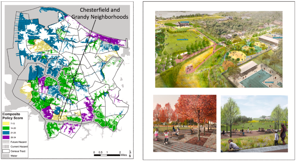
The PIRS evaluation reveals unexpected inconsistencies within Norfolk’s plan network between the district hazard zones. One example involves two poor minority neighborhoods that receive comparatively low composite policy scores in support for vulnerability reduction (see Chesterfield Heights and Grandy on Figure 1). These neighborhoods experience disproportionate losses from flooding and are projected to be exposed to severe levels of sea level rise (City of Norfolk, 2018).
Another example is that the location standards for infrastructure in the comprehensive plans do not include the criteria to steer public facilities away from several critical district hazard zones threatened by sea level rise. Yet, a prominent theme in Vision 2100 designates these zones for long-term shoreline retreat and relocation of existing development.
Finally, the hazard mitigation plan was developed in isolation from other plans. Notably, the urban planning staff were not aware that the city’s emergency management department was the lead participant in preparing the city’s element in the county mitigation plan. Consequently, important policies in the regional mitigation plan that deal with elevating, acquiring, relocating, and retrofitting structures conflict with the pro-development policies (up-zoning, tax abatements, etc.) in other plans across multiple districts.

Note. Adapted from Using a Resilience Scorecard to Improve Local Planning for Vulnerability to Hazards and Climate Change: An Application in Two Cities, by P. R. Berke, J. Kates, M. L. Malecha, J. H. Masterson, P. Shea, S. Yu, 2021, Cities, 119, p.6 (https://doi.org/10.1016/j.cities.2021.103408). Copyright 2021 by Elsevier Ltd.
“One of the big things we learned through the Scorecard process is that planning is taking place throughout the organization—not just in the planning department. There were lots of policy decisions being made outside of planning that we were not capturing in our comprehensive plan. [Guidance from] our Office of Resilience, which was relatively new, and even our Emergency Management [Office] with the Hazard Mitigation Plan—we weren’t fully taking into account when we were making recommendations.“Immediately, what we found was that when you go from a citywide level, with policies, and begin looking at how they impact at the neighborhood level, sometimes you can have unintended consequences. We really, truly want to make sure that all the polices are reflected in the comprehensive plan because decisions are made based on it.
“We [made] a series of amendments to the Comprehensive Plan to fully incorporate the Hazard Mitigation Plan and the Resilience Plan into it. Fortunately, now, we know [these plans] are part of our community and we are making them part of the comprehensive planning effort up front going forward.”
Paula Shea, AICP
Assistant Director of Planning
City of Norfolk, VA
References
Berke, P. R., Kates, J., Malecha, M. L., Masterson, J. H., Shea, P., & Yu, S. (2021). Using a Resilience Scorecard to Improve Local Planning for Vulnerability to Hazards and Climate Change: An Application in Two Cities. Cities, 119, 103408. https://doi.org/10.1016/j.cities.2021.103408
Berke, P. R., Masterson, J. H., Malecha, M. L., & Yu, S. (2020). Applying a Plan Integration for Resilience Scorecard to Practice: Experiences of Nashua, NH, Norfolk, VA, Rockport, TX [Preliminary report]. https://planintegration.com/cross-case-paper
City of Norfolk. (2017). Norfolk Vision 2100. Retrieved from https://www.norfolk.gov/DocumentCenter/View/27768/Vision-2100—FINAL?bidId=
City of Norfolk. (2018). Ohio Creek Watershed Project. https://www.norfolk.gov/3867/Ohio-Creek-Watershed-ProjectWork Program Architects. (2015). Dutch Dialogues VA: Life at Sea Level. https://wparch.com/dutch-dialogues-va-life-at-sea-level/

