Case Study Date: 2019; 2021
Asbury Park is a coastal city in New Jersey. It has a population of 16,116. Its geographic location along the Atlantic coastline exposes it to coastal flooding hazards.
Brief Summary of Findings
The overall plan network worsens the city’s vulnerability to flooding due primarily to its policy emphasis on facilitating developments in hazardous areas. Similarly, the equity policies in the plan network, overall, worsen vulnerability.
Plans Evaluated
- Asbury Park Master Plan
- Multi-Jurisdictional Hazard Mitigation Plan – Monmouth County, New Jersey
- Main Street Redevelopment Plan
- Waterfront Redevelopment Plan
- Central Business District Redevelopment Plan
- Consolidated Housing Plan (FY 2015–2019) [examined only in the PIRS analysis concerning equity policies]
- Scattered Site Redevelopment Plan [examined only in the PIRS analysis concerning equity policies]
Asbury Park, NJ
Asbury Park is located in east-central New Jersey, bordering the Atlantic Ocean. Once a famous vacation destination, the city has been in decline since at least the mid-1970s. Its 2010 population of 16,116 is projected to remain stable over the next 20 years (City of Asbury Park, 2006, as cited in Berke et al., 2019a). Asbury Park’s location on the Jersey shore is its greatest amenity, but also exposes it to coastal flooding hazards, as evidenced by the devastating impacts of Hurricane Sandy in 2012.

Findings of the Overall Network of Plans:
Asbury Park’s plan network has a mean policy score of -4.00, suggesting that the network generally increases the city’s vulnerability to flooding. This situation arises because Asbury Park’s plan network contains few policies supporting vulnerability reduction. On the contrary, it contains more policies encouraging development and intensifying land use in hazard-prone locations. Meanwhile, Asbury Park is the only city paying more policy attention to the more physically vulnerable districts among the six cities examined by the same study (the other five cities are: Washington, NC; League City, TX; Fort Lauderdale, FL; Tampa, FL; Boston, MA). It is reflected by the positive Pearson’s r correlation (0.01) between the degree of physical vulnerability of a district and the summed policy score there.
When concerning exclusively about equity policies, Asbury Park’s network of plan still have a negative mean score, which is among the most negative compared to other five plans being investigated by the same study. It suggests that the equity-policy portion of Asbury Park’s network of plan heightens vulnerability to flooding by a considerably high magnitude. Meanwhile, the Pearson’s r correlations between the summed policy scores and social vulnerability are -.50 and -0.21 for hundred-year floodplain and the projected sea level rise areas, respectively. The negative correlations suggest that the equity-policy portion of the plan network prioritizes risk reduction in districts with low social vulnerability.
Findings from Specific Case-Study – District 12:
District 12 of Asbury Park exemplifies the city’s conflict between recognition of flooding hazards and a focus on redevelopment to improve the city’s economy and quality of life. The district straddles downtown and the beach along Wesley Lake. It was formerly the city’s main entertainment hub, but all that remains are the abandoned Asbury Park Casino and Carousel House buildings.
The plan integration score of District 12 (-12) is the most negative among the city’s 11 districts. Physical vulnerability is considerably higher there compared to other districts, but there are many vacant and abandoned properties. About 42% (13 acres) of the district is located in the 100-year floodplain, including portions of the Asbury Park Boardwalk and the beach. West of the Boardwalk, current land use in the floodplain includes new multi-family residential and commercial developments, parking lots, and vacant properties.
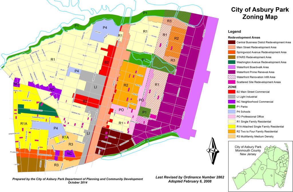
Three plans focus on District 12. The comprehensive plan and the waterfront redevelopment plan include policies designed to reduce flood vulnerability, such as zoning regulations that restrict the types of land use and structures permitted in certain places. Sensitive areas such as beaches and parklands are also preserved through zoning and capital improvement funding earmarked for enhancing shoreline vegetation. Notably, the hazard mitigation plan does not include policies that affect floodplain land use. Policies in this plan emphasize building code regulations and dredging drainage channels to facilitate movement of storm water runoff away from urban areas.
District 12 is also a central focus of the city’s Waterfront Redevelopment Area. Several prominent policy themes in the comprehensive plan and waterfront redevelopment plan work together to promote redevelopment and infill of vacant properties in the floodplain without considering hazard vulnerability:
- Smart growth concepts that allow increased densities and mixed uses in infill areas, and capital improvements for landscaping and pedestrianizing streets;
- Zoning overlays that support economic development by facilitating assemblage of properties for redevelopment, reuse of historic structures, and casino entertainment; and
- Development agreements that expand affordable housing for low- to moderate- income households.
References
Berke, P. R., Malecha, M. L., Yu, S., Lee, J., & Masterson, J. H. (2019a). Plan Integration for Resilience Scorecard: Evaluating Networks of Plans in Six US Coastal Cities. Journal of Environmental Planning and Management, 62(5), 901-920. https://doi.org/10.1080/09640568.2018.1453354
Berke, P. R., Yu, S., Malecha, M. L., & Cooper, J. (2019b). Plans that Disrupt Development: Equity Policies and Social Vulnerability in Six Coastal Cities. Journal of Planning Education and Research. https://doi.org/10.1177/0739456X19861144
Yu, S., Malecha, M. L., & Berke, P. R. (2021). Examining Factors Influencing Plan Integration for Community Resilience in Six US Coastal Cities Using Hierarchical Linear Modeling. Landscape and Urban Planning, 215, 104224. https://doi.org/10.1016/j.landurbplan.2021.104224

